|
 |
|
|
|
|
|
|
|
|
|
|
 |
|
|
|
 |
|
 |
|
|
For information
click here |
|
|
|
|
Route 1 -
Aboca, La Biforca, Pian della
Capanna, La Spinella, Germagnano |
|
| |
|
|
 |
|
|
|
total Km. |
37 |
|
Duration approx hrs. |
3.5/4.5
|
|
|
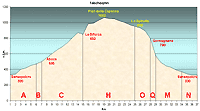
Altimetry
(click on the image to enlarge) |
The pictures |
path in
pdf
 |
| |
|
- Map
1
tracks
ABCHOQMN
- Aboca,
La Biforca, Pian della Capanna, La Spinella, Germagnano
- Total 37 Km.
-
Duration approx 3.5 - 4.5 hrs.
- Beautiful tract which runs for 14 kms in
high altitude trough country paths. High density of wild
fauna in this zone. Attention must be given to the
terrain in case of rain as the roads get muddy even if
it is only for two kms.
-
|
 |
|
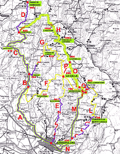
Legenda |
| |
Country paths |
| |
|
| |
Asphalt |
| |
|
| |
Rampichino |
| |
|
|
| |
Itinerary
map
(click on the image to enlarge) |
| |
|
- A
(6Km)
- along the S.S.Tiberina 3Bis road in the direction of
Pieve S.Stefano, after 2 kms from the historic center, a
flat road arriving at a roundabout Continuing
right in the direction of Rimini, the perfectly
asphalted road starts climbing uphill and leading out of Sansepolcro
with road signs that indicate the kms in English and
after about a hundred Kms in Roman numbers. After 3Kms
uphill the road becomes flatter and downhill in tracks
for 5 kms, where it is well visible a deviation on the
right on a country path with light blue road signs for
Acquitrina.
- B
(1Km)
- continuing
on the asphalted road that is practically flat, there is
the "Aboca Erbe" company and after this the
restaurant "Osteria di Aboca".
- C
(8 Km)
- further along starts the uphill ride which brings is to
the "Passo of Viamaggio", continuing for many
kilometers uphill which brings us to winding
Mountain-tarred road always in ascent. On the left we
will find the road to Castelnuovo (check map2) and the
tarred road continues for approx 15 kms. One needs to be
careful while following the next tract. The countryside
present it self as two "camel humps", two
mountainous "points" that we will pass by on
the left of the tarred road. This is the "Passo
della Traforata". Immediately after the curve on
the right there is a deviation on a country path on the
right quite a large wooden gate with a few indications
and an orange board. We have to climb here.
- H
(10 Km)
- once through the wooden gate the road starts to climb steeply and the terrain is quite stony
and ruinous which after a brief ride brings is to 1000
mt in altitude and after downhill and again uphill
through beautiful woods and green fields. The road may
sometimes be muddy or in the case of the ascent of
Bastione, stony. In any case the surroundings are really
stupendous and isolated and it’s easier to meet
animals than humans. This route winds through diverse
types of terrain until we reach a rustic house called
"Pian dell Capanna" at 1.062 mts s.l.m.,
perfectly restored and furnished for picnics and rest
stops. It is possible to have a barbecue and there is
also drinking water. Further along the road there is
another house called la " Spinella" where the
cyclist can chose the descent (check map 1, tract
o and p)
- O(3
Km)
- Straight on after leaving "la Spinella" on
the left the road starts climbing again towards the woods for approx 400 mt, after which there is a
lovely downhill tract through the woods with good
terrain. At the bottom of the descent there is a fork in
the road and if we are following this proposal of rout,
deviate left to the small village of Germagnano.
- Q(1Km)
- just
1 km down a steep decline 15% to 20% will bring you to a
tarred road that passes through a farmhouse and
surrounding outhouses. After a few curves we will reach
the tarred road that will load us to Sansepolcro,
turning on the right.
- M(5
Km)
- this
route is completely tarred end the decline is not
particularly difficult although very fast. Very soon
after a bridge situated on a curve of the road there is
a drinking fountain only 4 kms from the center of
Sansepolcro. From here on there is a slight uphill climb
and then all downhill again which takes us to the fork,
which if taken on the left will lead to the Sanctuary of
Monte Casale.
- N(3
Km)
- however if we continue on
the road we will arrive in the center of Sansepolcro.
-
|
| |
|
 |
|
|
|
|
|