|
 |
|
|
|
|
|
|
|
|
|
|
 |
|
|
|
 |
|
 |
|
|
For information
click here |
|
|
|
|
Route 2 -
Acquitrina, La Calla, Monte Vicchi |
|
| |
|
|
 |
|
|
|
Total Km. |
25 |
|
Duration approx hrs |
2/3 |
|
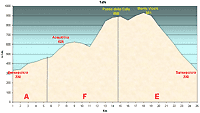
| Altimetry
(click on the image to enlarge) |
the pictures |
path in
pdf
 |
| |
|
- Map
1 tracts
AFE
-
Acquitrina, La
Calla, Monte Vicchi
-
Total 25 Kms
-
Duration approx 2 - 3 hrs
- Demanding
but beautiful, route especially on the tract F. Two
factors to be careful - the ground is muddy in case of
heavy rain and in the horseflies in summer are numerous.
|
 |
|
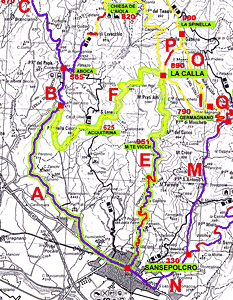
Legenda |
| |
Country paths |
| |
|
| |
Asphalt |
| |
|
| |
Rampichino |
| |
|
|
| |
Itinerary
map
(click on the image to enlarge) |
| |
|
-
A
(6Km)
-
along
the S.S.Tiberina 3Bis road in the direction of Pieve
S.Stefano, after 2 kms from the historic center, a flat road
arriving at a roundabout.
Continuing right in the direction of Rimini, the
perfectly asphalted road starts climbing uphill and leading out
of Sansepolcro with road signs that indicate the kms in
English and after about a hundred Kms in Roman numericals.
After 3Kms uphill the road becomes flatter and downhill in
tracks for 5 kms, where it is well visible a deviation on
the right on a country path with light blue road signs for
Acquitrina.
-
F(9
Km)
-
Da questo momento la strada
diventa impegnativa e sterrata, il fondo è in eccellente
stato, ben battuto. Si consiglia di utilizzare rapporti
agili e iniziare la salita di due chilometri circa che ci
porta alla località Acquitrina. In pratica dopo qualche
curva tra i campi e poi i boschi si arriva ad un rettilineo,
sempre in salita, che termina sul crine della collina ove in
basso si vede Sansepolcro, preceduto da pascoli e un
allevamento, e poco a sinistra in alto si vede una casa
colonica piuttosto grande. Questa è località Acquitrina a
625 mt. s.l.m., nei pressi della casa c’è una fonte a cui
abbeverarsi. Si prosegue per la strada sulla sinistra e dopo
un breve tratto di discesa continua in salita con un buon
fondo stradale attraversando casolari e poi boschi. La
strada non ha alternative quindi non permette di incorrere
in errore. Dopo una curva a destra si scende per risalire
alla curva successiva. A un certo punto si trova uno
sbarramento di legno, un cancello che facilmente si può
superare e da questo momento il terreno diventa più infido,
sconnesso e, in caso di pioggia, fangoso per cui la salita è
ancora più impegnativa. Anche la vegetazione cambia e
troviamo conifere ai lati del percorso. Questo tratto
termina con un altro sbarramento, un cancello facilmente
superabile che ci indica che siamo allo sbocco della Calla a
890 mt. s.l.m..
-
-
E(10Km)
- from
here there are many different roads described in other
itineraries (tracts e, i, p, g, f) and the cyclist can
choose different destinations. To reach Monte Vicchi the
road turns right and after a brief descent, we came out in
a road that continues on the right. Here the ascent is
mild on the terrain is normally perfect. Along this road
can be admired centuries old trees in woods as beautiful,
and find picnic areas with drinking fountains. At the end
of the climb, at 951 m.s.l.m., the road takes a natural
right following the tract we will reach again the tarred
road and a very steep downhill ride. The view is on the
entire Tuscan Valley of the Tiber (Valtiberina Toscana)
and at the bottom of the mountain is spread out the city
of Sanseolcro, the road ends in the city center.
This road can be taken also in the opposite direction, the climb is very
demanding even if the road is well asphalted but the descent
of tract A and F is extremely pleasant.
|
| |
|
 |
|
|
|
|
|