|
 |
|
|
|
|
|
|
|
|
|
|
 |
|
|
|
 |
|
 |
|
|
For information
click here |
|
|
|
|
Route
4 -
Germagnano, Passo della Calla,
Monte Vicchi |
|
| |
|
|
 |
|
|
|
total Km. |
22 |
|
Duration approx hrs |
2/2.5 |
|
|
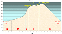
Altimetry
(click on the image to enlarge) |
the pictures |
path in
pdf
 |
| |
|
- Map
1
traks
NMQIE
-
Germagnano, Passo della Calla, Monte
Vicchi
-
-
Total 22 Kms.
- Duration approx
2 - 2.5
hrs
- A
brief but intense route with a demanding ascent and a
panoramic descent of the Valtiberina.
|
 |
|
Legenda |
| |
Country paths |
| |
|
| |
Asphalt |
| |
|
| |
Rampichino ??? |
| |
|
|
|
| |
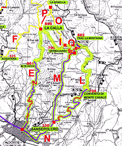
Itinerary
map
(click on the image to enlarge) |
| |
|
-
N (4 km)
- from Sansepolcro, along the state road towards the
direction of San Giustino and Città di Castello, the
hotel "La Balestra" can be seen passing on the
left and the road signs for Monte Casale. We turn left
along this direction until we reach the road sign for
Monte Casale on the right, no need to continue as the
tract N ends here.
-
-
M
(5 km)
- continuing along the road in direction "La
Montagna" ,(tarred road) you will meet quite a few
uphill tracts until one reaches a curve which passed over
a bridge with a fountain to one side on the right after
which is the uphill tract called Gotiche, steep but
quite brief (approx 1Km) continue until you arrive to a
curve to the left that leads to a pebble road and a blue road
sign indicating Germagnano.
-
Q
(1 km)
- going along the pebble road, which is about 1Km with a
steep ascent (15% to 20%) not easy for beginners. Continue
along about 300 mts you will come to the agricultural
community of Germagnano. Further along you will arrive at a
fork in the road from which you can take tract O or
I
.
-
I
(4 km)
- continuing
on the left road uphill for 200 mts, the road is a
perfectly beaten one and runs through a tract surrounded
by splendid trees and wonderful landscape. The tract
finishes at the crossroad of the Calla pass. From here you
can choose different courses, as you can see from Map1,
but if you want to return to Sansepolcro it's enough o
continue the same road leaving the brief ascent to the
pass and the gate on the high right.
-
E (8 km)
- here the road is still gradually uphill and the terrain
is perfect. At the end of the climb, 951 mt. s.l.m.
following the road in a curve right you will come to the
tarred road and a very steep downhill tract. The landscape
faces the whole view of the Valtiberina Toscana and under
the mountain is spread out the city of Sansepolcro, The
road ends in the town.
|
|
|
|
 |
|
|
|
|
|