|
 |
|
|
|
|
|
|
|
|
|
|
 |
|
|
|
 |
|
 |
|
|
For information
click here |
|
|
|
|
Route 5 -
Germagnano, La Spinella, Passo
della Calla, Monte Vicchi |
|
| |
|
|
 |
|
|
|
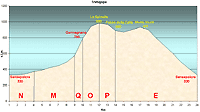
total Km. |
24 |
|
Duration approx hrs |
2/2.5 |
|
|
Altimetry
(click on the image to enlarge) |
the pictures |
path in
pdf
 |
| |
|
- Map
1 tract
NMQOPE
-
Germagnano, La Spinella, Passo della Calla, Monte
Vicchi
-
-
Total 24 Km
- Duration
approx 2 - 2.5
hrs
- Demanding
tract were the path is beaten but with the surrounding
landscape worth the effort.
|
 |
|
Legenda |
| |
Country paths |
| |
|
| |
Asphalt |
| |
|
| |
Rampichino |
| |
|
|
|
| |
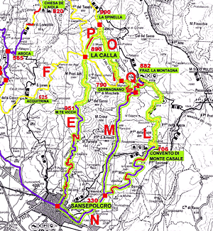
Itinerary
Map
(click on the image to enlarge) |
| |
|
-
N (4 km)
- from
Sansepolcro, following the state road in direction of San
Giustino Umbro and Città di Castello, you will pass the
hotel La Balestra on the left followed by a diversion on
the left for Monte casale. You have to follow this road
straight on without turning of at any point. After 1 Km
you will see the indication for Monte Casale on the right,
the tract N finishes here.
-
M
(5 km)
- continuing
on this road towards the locality of la Montagna, the road
is an asphalt one and always uphill curving over a bridge,
with a fountain on the right, after which you will come to
the ascent of the Gotiche, demanding but brief, approx 1
Km until you arrive at a left hand curve in the road with
a diversion on a beaten road indicating Germagnano.
-
-
Q
(1 km)
- taking
the direction of the dirt road for 1 Km the climb is quite
notable (15% to 20%) which is quite difficult for
beginners. Unfortunately it is obligatory this climb even
if done on foot, to reach the other tracts that
successively lead off from it. When the road levels off (about
300mts) you will find the agricultural farm Germagnano,
from which continuing along this road you will reach a
fork from which you can take tracks O or I.
-
O
(2 km)
- For this route you have to take the right turn at the
fork along a dirt road, which you will find in some places
a road climb uphill but the woods and meadows along will
really give you great pleasure, and it is quite common to
meet deer and roebuck. When you have reached the top you
will be at approximately 1000 m. slm and descending always
through the woods on the right it is possible to see the
house, Spinella, and the monument to the war victims. To
arrive at monte Vicchi you must before arriving at the
Spinella, take the first road on the extreme left. Take
note that arriving at the Spinella you are on a beautiful
rim and carrying on this same road beside the house you
will reach Pian della Capanna and the tract H
-
-
P
(2 km)
whereas if you continue on the extreme left road you will
return through the woods and after a few hundred meters the
descent becomes quite rapid and steep. If it has been
raining this road gets quite muddy. At the end of the
descent you will arrive at the Passo della Calla, 890 mt.
s.l.m. You can recognize it easily by the gate on the right
and you can choose the route to go downhill that you prefer.
It is sufficient to continue at right downhill on the some
road for 50 mt. and deviate on the road to the right which
although a dirt road is in pretty good condition.
-
E (10 km)
- Here the climb is gradual
and the terrain is normally perfect. You can admire
beautiful trees and woods along which are picnic areas where
you can find drinking fountains. At the top 951 mt. s.l.m.,
the road curves naturally to the right and you will meet the
tarred rood and a downhill tract which is quite steep. The
landscape faces the whole Valtiberina Toscana and under the
mountain, the city of Sansepolcro is spread out and the road
ends in the town.
|
|
|
|
 |
|
|
|
|
|