|
 |
|
|
|
|
|
|
|
|
|
|
 |
|
|
|
 |
|
 |
|
|
For information
click here |
|
|
|
|
Route 8 -
La Montagna, Vesina, Monte Casale |
|
| |
|
|
 |
|
|
|
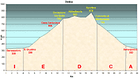
total Km. |
22 |
|
Duration approx hrs |
2.5/3.5 |
|
|
Altimetry
(click on the image to
enlarge) |
the picture |
path in pdf
 |
| |
|
- Map
3
tracts
ABCA
- La
Montagna, Vesina, Monte Casale
-
total 22 Km.
-
Duration approx 2.5 - 3.5
hrs
-
This route is demanding but permits you to ride a varied
uphill and downhill beaten single track for kilometers,
remaining always in altitude. Beautiful for the rock
formations, woods and uncontaminated nature.
|
 |
|
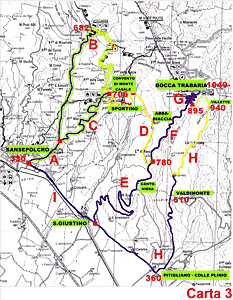
Legenda |
| |
Country paths |
| |
|
| |
Asphalt |
| |
|
| |
Rampichino |
| |
|
|
| |
Itinerary
Map
(click on the image to enlarge) |
| |
|
-
A (3 Km)
From Sansepolcro, along the state road in the direction San
Giustino Umbro and Città di Castello, you will pass the
hotel La Balestra on the left followed by a deviation for
Monte Casale. Follow this road and after 1 km you will see
the indication for Monte CAS ale on the right. Here tract A
ends. 50m ahead of the deviation, there is a small church on
the left, which if open is worth visiting for the antique
painting on the walls.
-
B
(12 Km)
-
Continuing down this road towards the small village Montagna,
the road is well tarred and there are a few tracts uphill
before you ride over a bridge situated on a curve of the
road. This preludes the uphill climb called the Gotiche,
brief but demanding, about 1 km long. This road leads to a
curve on the left which is a dirt road with a blue sign
indicating Germagnano. Continue along this road and after a
bridge you will realise that the road presents an uphill
climb that grows slowly quite demanding, for 2 km until you
reach Montagna (682 mts s.l.m.). Immediately, on arriving at
the little village you will find a wall in front with a
cross. On the left of this you will find the village, two
restaurants and one bar. Our tract follows the right main
road. Now the road is quite flat and in reaching the end of
the tarred road, there is a beaten track of excellent
condition that is navigable in any kind of weather. The road
starts to climb and will lead to the locality of Pischiano
(748 mt s.l.m.), the terrain is les perfect and in between
two houses on the way you will come across a fountain. On
the left the path leads you to the Passo delle Vacche, it's
advisable the path on the right to complete this tract. You
descend down a brief pathway which crossed a stream at the
end. Hereon the path starts climbing through rocks until it
reaches the rim visible high above. The climb is brief but
difficult and at the end is a stupendous landscape. Careful
attention should be taken on this tract especially on the
rocky rim; from here on the left there is a small pathway
that is hardly visible, this is the continuation of the
tract, the one visible thing that indicates the correct
direction is a red-white and red marks designed on the rock
to indicate the way. Hereon this tract is really
spectacular: it climbs and descends trough woods, rocks and
small streams. The terrain is varied and not always easy.
You will finally arrive at rolling meadows and the old
abandoned village Vesina, after which passing trough the
woods, you will reach the last part of the tract, turning
right and following the path that broadens and passes by the
convent of Montecasale (709 m.s.l.m.) the view from the
convent is worth stopping for and for a brief visit of a
much treasured spot to the people of this region. From here
the road is well tarred and leads to Sansepolcro.
-
C (5 Km)
-
A road full of towns and curves with a steep downhill
descent, through woods and meadows until you reach a stop
signal on the road. Here you turn left.
-
-
A (2 Km)
-
Following this road, you will cross over a bridge on the
river Afra, very soon you will be at the residential centre
of Sansepolcro.
|
| |
|
 |
|
|
|
|
|