|
 |
 |
 |
 |
 |
 |
 |
 |
 |
 |
 |
 |
 |
 |
 |
 |
 |
 |
|
For information
click here |
|
|
|
|
Route 9 -
Via Giulia, Abbadiaccia, Sportino,
Montecasale
(convento) |
|
| |
|
|
 |
|
|
|
total Km. |
24 |
|
Duration approx hrs |
2.5/3 |
|
|
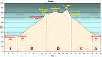
Altimetry
(click on the image to
enlarge) |
le immagini |
il percorso in
pdf
 |
| |
|
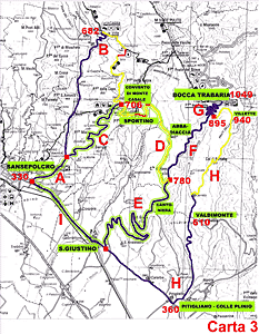
- Map
3
tracts
IEDCA
- Via
Giulia, Abbadiaccia, Sportino, Montecasale (Convento)
-
total 24 Km.
-
Duration approx 2.5 - 3 hrs
-
This is a route of extraordinary beauty because it combines
history, art and nature wild. Gradual climbs on tar and ups
and downs single tract beaten paths. It is an absolute must
to do hoping that the weather does not deteriorate too much
and so doing ruin the terrain that is to be traversed.
|
 |
|
Legenda |
| |
Country paths |
| |
|
| |
Asphalt |
| |
|
| |
Rampichino |
| |
|
|
| |
Itinerary
Map
(click on the image to enlarge) |
| |
|
-
I
(4 Km)
-
Starting from Sansepolcro along the state road Tiberina 3bis
towards San Giustino Umbro the tract is simple, flat and
road passes the entrance to the Bufalini castle. Carry on
upwards to your right where you will reach an important
crossroad.
-
E
(7 Km)
The left rood takes you to the Apennine mountain pass of
Bocca Trabaria, that points you in the directions of Fano.
The road is a continuing climb with quite a lot of traffic.
The uphill start has a characteristic that it permits the
biker to use just one gear from start to finish of the
climb. This makes this road an ideal practice climb for
those who do not love uphill rides. Continuing on the right
of the road you will see a red coloured house with "casa
cantoniera" written on it. After one kilometre you will see,
a deviation on the left of a beaten track immediately after
a left curve. Here there is a road sign with "Via Giulia" on
it, (780 mt. s.l.m.) and a gate. The Via Giulia is an
antique Roman route that reserves surprises.
D
(6 Km)
-
The road is well beaten for at least 1 km. After which you
will find a cattle gate that should be closed. Carefully
after passing through. Passing through a wood you will find
in front of you the Abbadiaccia (822 mt s.l.m.) a locality
whit a fascinating name that suggest to our imagination
mystery and history. The little village today is used as a
cattle farm but there is still a beautiful watchtower built
by the longobards. Continuing on the terrain begins to
deteriorate and descends to a stream to be crossed, after
which a short steep climb (terrain difficult) you will
arrive at the second watchtower of the longobards. The path
continues uphill and downhill and although there is other by
paths you should stay on the principal track. The landscape
is wild and the knowledge that you are travelling a historic
though minor, road is fascinating. After a brief run you
will meet the third tower on this route. Going on you will
climb towards Sportino (873 mt s.l.m.); rapid curves and
rocky terrain will bring you upwards to the top of the pass
before the downhill ride towards Montecasale. As you arrive
to the rim you will realise that the track runs along the
precipice but from here descends down rocky and impervious
terrain, then through beautiful woods and joining a pathway
that is brooder and which we will describe in the next route
from here we take the left and passing by a youth hostel at
the edge of the wood, you arrive at Montecasale (709 mt
s.l.m.) from here the road is asphalted and following it you
will arrive at Sansepolcro.
-
C
(5 Km)
-
Curves and turns and downhill ride through woods and meadows
brings you to a stop signal from which you take the left.
-
A (2 Km)
-
Continuing on this road, you will cross a bridge on the
river Afra and arrive very soon to the state road Tiberina 3
bis and the residential centre of Sansepolcro.
|
| |
|
 |
 |
 |
 |
|