|
For information
click here |
|
|
|
|
Route
11 - Il giro della Diga
Montedoglio (only tarred road) |
|
| |
|
|
 |
|
|
|
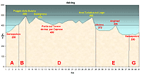
total Km. |
41 |
|
Duration approx hrs |
1.5/2.5 |
|
|
Altimetry
(click on the image to
enlarge) |
the picture |
path in pdf
 |
| |
|
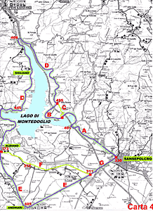
- Map
3
tracts
ABDEG
- The Montedoglio
dam
-
total41
Km .
-
Duration approx
1.5 - 2.5 hrs
Simple and varied route, perfect for those who like the
overage difficulty with changing landscape. This route is
almost completely around the lake of the Montedoglio dam
and is suitable even for beginners.
|
 |
|
Legenda |
| |
Country paths |
| |
|
| |
Asphalt |
| |
|
| |
Rampichino |
| |
|
|
| |
Itinerary
Map
(click on the image to enlarge) |
| |
|
-
A
(5 Km)
-
from Sansepolcro along the state road towards Pieve Santo
Stefano, after a roundabout, which is a crossroads for those
going to Rimini, the road climbs gradually and after a curve
on the left goes down under the highway E45 and climbs again
to continue towards the lake which you will see in the
distance. The road continues up an down under the E45 until
you reach, in the middle of the climb, a deviation well
visible on the right going decisively uphill and a beaten
path.
-
B
(2 Km)
-
This continues always on the tarred road to reach a bridge
that is of the same height of the beginning of the lake.
From here you climb towards the locality Madonnuccia. The
climb continues and after a brief descent, you will find a
very short but "poissonous" climb in front of you to be
traversed at the top of which we will go left.
-
D
(21 Km)
Uphill and downhill, flats and curves the road runs for
several kilometres along the lake until you reach the
deviation for Sigliano clearly indicated on the left. It
then passes under the highway after which it crosses a
bridge on the river Tiber. Along here you will see a
breading farm for horses (Formole). The road is flat and
passes a small, graceful church barely visible above the
road. From here you have three uphill slopes after which you
descend to reach a bridge on the mouth of the river Singerna
which enters in to the lake. After this bridge the road
climbs until you reach a terrace over the lake. Continuing
on the right we will reach the road leading to Caprese
Michelangelo. Here we should take the road on the left
downhill over a bridge to pass after which you will see a
deviation on the left. Continue on the tarred road.
-
E
(10 Km)
You will now pass the locality of "La Motina". The traffic
is not too heavy and the road is quite flat until you reach
the climb towards Anghiari and the deviation for Sansepolcro
in descent. Going downhill you will reach the plain of
Valtiberina and the road crosses the little town of Santa
Fiora where the tract ends.
-
G
(3 Km)
Continuing along this road, you will reach a stop sign where
you should turn left and after going through an under
passage that is under the highway you will reach Sansepolcro.
|
| |