|
 |
|
|
|
|
|
|
|
|
|
|
 |
|
|
|
 |
|
 |
|
|
For information
click here |
|
|
|
|
Route13 -
Valsavignone,
Cirignone, Passo delle Gualanciole, Poggio dei Tre
Vescovi |
|
| |
|
|
 |
|
|
|
total Km. |
37 |
|
Duration approx hrs |
2.5/3.5 |
|
|
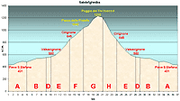
Altimetry
(click on the image to
enlarge) |
the picture |
path in pdf
 |
| |
|
- Map
5
tract
ABDEFGHEDBA
-
Valsavignone, Cirignone,
Passo delle Gualanciole, Poggio dei Tre Vescovi
-
total 37 Km .
-
Duration approx 2.5 - 3.5 ore
Route very similar to the previous one as it follows
almost in the same tracts. Actually the Poggio dei Tre
Vescovi and the woods thath sourround it merits a route of
it's own because of it's beauty
|
 |
|
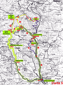
Legenda |
| |
Country paths |
| |
|
| |
Asphalt |
| |
|
| |
Rampichino |
| |
|
|
| |
Itinerary
Map
(click on the image to enlarge) |
| |
|
-
A
(5 Km)
From Pieve Santo Stefano in direction of Verghereto along
the state road. As soon as you leave the turn (well tarred)
with not too much traffic starts climbing slightly but
constantly. A good way to warm up cold muscles before the
real climb. The tract ends where you see the road sign for
Bulciano.
-
B
(4 Km)
continuing on the same road, which is now much more level,
you will arrive most naturally to the next point in the
route
-
D
(1 Km)
continuing you will find just after a bridge some houses.
This is a village Called Valsavignone (560 mt.s.l.m.) On the
left, between the houses, there is a road which is indicated
by signboards the places that we have to go to (Cirignone,
Passo della Gualanciole, etc...). We will deviate exactly on
this road.
-
E
(4 Km)
-
If you turn off to the deviation on the left, the road is
still tarred although not in very good condition. It starts
immediately to climb although the first part is quite
gradual until you are able to see the village of Cirignone.
At this point the incline is very demanding and after a few
curves you will arrive at the village of Cirignone (845
mt.s.l.m.) and from hereon starts the beaten path through
the woods.
-
F
(3 Km)
arriving at the village, at the first curve, you will see
the woods and the mountain. Follow this road which is beaten
but in good condition. Once into the woods the road climbs
up steeply and curving upwards leads you to the top and the
Passo delle Gualanciole (1040m.s.l.m.). An enchanting place
from witch you can see in front Casentino.
-
G
(4 Km)
-
From the pass you take the road towards the right and climb
upwards towards the woods. The road is beaten and not in
very good condition, toy must follows it keeping always to
the right of the track. Entering the woods you will enter a
world of fantasy, nature a it best, coniferous and beech
trees. For 2 kms you will continuing to climb always trough
woods until you reach the highest point which is Poggio dei
Tre Vescovi (1232 mts.s.l.m.) after which obviously you
start the downhill descent. The terrain is not so good and
after approx. 100 m. you will see a deviation on the left
which we should not follows (as I do not know where it
leads as) but here ends tract G.
-
H
(3 Km)
You will descent this pathway with pleasure as it is very
beautiful even if you leave behind the woods very soon. The
road quality improves and we find ourselves at a fork. Take
the right road and continue the descent down the territory
along the side of the mountain until you find the tarred
road, a downhill ride which is very steep and brief, after
which you pass the locality of Cirignone (845 m.s.l.m.)
where you have reached the curve from where the path starts
which we had previously taken.
-
E
(4 Km)
Now descending alongside a river we will go along the same
tarred road that we passed to climb up to Cirignone until we
reach the state road and turn right
-
D
(1 Km)
- Nothing important
-
B
(4 Km)
- Continuing substantially
downhill
-
A
(4 Km)
- And you will reach Pieve
Santo Stefano.
|
| |
|
 |
|
|
|
|
|