|
 |
|
|
|
|
|
|
|
|
|
|
 |
|
|
|
 |
|
 |
|
|
For information
click here |
|
|
|
|
Route 14 -
Valsavignone,
Cirignone, Passo delle Gualanciole, Passo delle Pratelle,
Montalone |
|
| |
|
|
 |
|
|
|
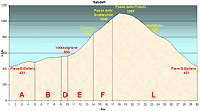
total Km. |
30 |
|
Duration approx hrs |
2.5/3.5 |
|
|
Altimetry
(click on the image to
enlarge) |
the picture |
path in pdf
 |
| |
|
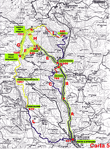
- Map
5
tracts
ABDEFL
-
Valsavignone, Cirignone,
Passo delle Gualanciole, Passo delle Pratelle Montalone
-
total 30 Km .
-
Duration approx
2.5 - 3.5 hrs
this route is lovely and varied and takes you in altitude
across a gradual and continuing uphill climb. Nature wild
with the possibility to meet along the way roe buck and
deer in the woods. The landscape of Casentino all around
you makes this one of the most beautiful routes of our
zone.
|
 |
|
Legenda |
| |
Country paths |
| |
|
| |
Asphalt |
| |
|
| |
Rampichino |
| |
|
|
| |
Itinerary
Map
(click on the image to enlarge) |
| |
|
-
A
(5 Km)
-
From Pieve Santo Stefano in direction of Verghereto along
the state road. As soon as you leave the turn (well tarred)
with not too much traffic starts climbing slightly but
constantly. A good way to warm up cold muscles before the
real climb. The tract ends where you see the road sign for
Bulciano.
-
B
(4 Km)
-
continuing on the same road, which is now much more level,
you will arrive most naturally to the next point in the
route
-
D
(1 Km)
continuing you will find just after a bridge some houses.
This is a village Called Valsavignone (560 mt.s.l.m.) On the
left, between the houses, there is a road which is indicated
by signboards the places that we have to go to (Cirignone,
Passo della Gualanciole, etc...). We will deviate exactly on
this road.
-
E
(4 Km)
If you turn off to the deviation on the left, the road is
still tarred although not in very good condition. It starts
immediately to climb although the first part is quite
gradual until you are able to see the village of Cirignone.
At this point the incline is very demanding and after a few
curves you will arrive at the village of Cirignone (845
mt.s.l.m.) and from hereon starts the beaten path through
the woods.
F
(3 Km)
arriving at the village, at the first curve, you will see
the woods and the mountain. Follow this road which is beaten
but in good condition. Once into the woods the road climbs
up steeply and curving upwards leads you to the top and the
Passo delle Gualanciole (1040m.s.l.m.). An enchanting place
from witch you can see in front Casentino.
-
L
(13 Km)
-
from the Passo delle
Gualanciole you take the road left and
continue upwards trough meadows. The last bit of the ascent
is easily recognisable because it is a straight line running
along a rocky wall on the top, always on the lower left is a
fountain from which you can refresh yourself with a drink of
fresh water. In the summer it is really a "delizie". Thus on
the top we are close to the Passo delle
Pratelle (1067
m.s.l.m.) and we will continue to follow the road which is
now on the level for a good part, with an extraordinary
panorama which includes a view of Monte Penna where is
situates the Sanctuary of La Verna. The road starts to
improve and begins the long descent amidst curves and woods.
At the end of this beaten road you will be the locality of
Montalone (870 m.s.l.m.), and re-enter the tarred road where
you should turn left to reach after a few kilometres of
downhill the point of departure, from which you started i.e.
Pieve Santo Stefano.
|
|
|
|
 |
|
|
|
|
|