|
 |
|
|
|
|
|
|
|
|
|
|
 |
|
|
|
 |
|
 |
|
|
For information
click here |
|
|
|
|
Route 15 -
Montalone, Passo delle Pratelle, Monte Calvano, La
Verna, Passo dello Spino |
|
| |
|
|
 |
|
|
|
total Km. |
33 |
|
Duration approx hrs |
2.5/4 |
|
|
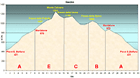
Altimetry
(click on the image to
enlarge) |
the picture |
path in pdf
 |
| |
|
- Map
6
tracts
AECBA
-
Montalone,
Passo delle Pratelle, Monte Calvano, La Verna, Passo dello
Spino
-
30 Km total.
-
Duration approx
2.5 - 4 hrs
Route very demanding because of the stiff uphill climb on
tract
E, but worth while for the scenery and nature.
Care should be taken on the road between the passo
delle
Pratelle
and La Verna, as in case of heavy recent rains the terrain
will surely be heavy going. Lastly worth visiting is the
monastic Sanctuary of La Verna.
|
 |
|
Legenda |
| |
Country paths |
| |
|
| |
Asphalt |
| |
|
| |
Rampichino |
| |
|
|
| |
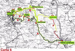
Itinerary
Map
(click on the image to enlarge) |
| |
|
-
A
(8 Km)
a very demanding route because of the stiff slopes of tract
E, even thought it is one of the most beautiful. Care should
be taken on the road between the passo
delle
Pratelle
and La Verna, as in case of heavy recent rains the terrain
will surely be heavy going. Lastly worth visiting is the
monastic Sanctuary of La Verna..
-
E
(7 Km)
-
at Montalone, you enter the centre of town and follow the
only road which takes you up a gentle slope until you reach
a fork on a beaten path. You must take this rod that climbs
left and continues upward trough the woods along a well
beaten path that arrives well over 100 mt.s.l.m.. After
about 4 KM you will arrive at a fork where there is a road
sign for La Verna. Follows this direction and very soon you
will find that the terrain deteriorates and if there has
been recent rains, then it becomes quite rough. Continuing
on this path you will cross meadows and gates (which we ask
you to close every time). After some time you will enter
some woods. Coming out of which you will reach a road in
front right and you have just come from. Turn right and you
will leave behind the woods and find yourself at the top of
the mountain, on the right, no trees but a huge meadow. We
will keep to the very top (1254 mt.s.l.m) we now continue to
follow the direction of the path which is very faintly
visible on the ground and descent until we can see the
Sanctuary of Verna (1132m.s.l.m). The terrain is quite
trough here and in some places it will be necessary to get
of your bicycle and push. When we reach a fork in the road
at the end of a slope on the escarpment we have wish to
take. There are two alternatives: C- take the road on the
right for the Sanctuary and then return downwards to the
valley through the tarred road following the indications of
the road signs for Pieve Santo Stefano. D- The alternative
is to continue on the state road at the "Passo dello
Spino".
-
C
(6 Km)
After you have paid a visit to the Sanctuary of Verna (which is warmly advised) you return on the state road which
is tarred and go downhill for a couple of curves until the
road deviates to the left at a stop signal. The descent
continues another Kilometre after which the road continues
uphill gradually until you reach the "Passo dello Spino"
(1055m.s.l.m.)
-
B
(4 Km)
-
after the pass the road curves downhill until you reach
Montalone (870 mt.s.l.m)
-
-
A
(8 Km)
without any difficulty we will continue downhill until we
reach the town of Pieve Santo Stefano
|
|
|
|
 |
|
|
|
|
|