|
 |
|
|
|
|
|
|
|
|
|
|
 |
|
|
|
 |
|
 |
|
|
For information
click here |
|
|
|
|
Rout 18 -
Anghiari,
Badia di S. Veriano o Alpe di Poti |
|
| |
|
|
 |
|
|
|
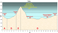
total Km. |
24 |
|
Duration approx hrs |
2.5/3.5 |
|
|
Altimetry
(click on the image to
enlarge) |
the picture |
path in pdf
 |
| |
|
- Map
7
tracts
ADE(F)G
-
Anghiari,
Badia di S. Veriano o Alpe di Poti
-
24 Km totali.
-
Tempo necessario circa
2.5 - 3.5 ore
This
route is beautifu, varied, demanding on the uphill slopes.
the terrain is always in good condition even in case of
heavy rains. Very beautiful landscapes like
la Badia. Beautiful but very demanding in the opposite
direction.
|
 |
|
Legenda |
| |
Country paths |
| |
|
| |
Asphalt |
| |
|
| |
Rampichino |
| |
|
|
| |
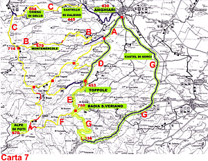
Itinerary
Map
(click on the image to enlarge) |
| |
|
-
A
(2 Km)
-
from Anghiari,(430 mt s.l.m.)
near the Campo alla Fiera (easy to find it is a zone with
gardens and car parks, it is better if you ask someone for
directions, everyone knows the point) you must take the road
that descends between the houses on the opposite side of the
landscape that looks down on Sansepolcro. After 1 km of
downhill you will arrive at a fork.
-
D
(4 Km)
take the left, direction Toppole. The road is well tarred
and there is not much traffic, therefore it is a pleasant
route which after a while starts to climb. As soon as you
will at Toppole, in truth a group of houses, you will see a
deviation on the left that climbs very steeply uphill.
-
E
(2 Km)
Taking this tract, the road is demanding but with a
landscape that makes it worthwhile. It passes through woods
of oak trees that will lead on to a dirt road to the crest
of the ridge where you will decide the road to take. When
the road becomes almost on a level you will arrive at a four
crossroad (690mt.s.l.m). Here take the left, in gradual
climb uphill to cover the kilometre to reach the Badia
S.Veriano (760 mt.s.l.m.), a beautiful and isolated spot
with a medieval church, a cypress wood, a panorama that
looks on the Valtiberina with the possibility of areas for
picnics and a drinking fountain. to return to Anghiari you
have to return to the 4 crossroads. Alternatively we could
upwards towards the Alpe di Poti to reach the radio
transmission tower which we can see high above us. This is
the tract F of Map 7. From this road there is still a lot of
climb which becomes really steep in the final part, to reach
the top of the mountain in front of us. The peak (970 mt
s.l.m), exactly where the radio transmission tower is found,
you can see Arezzo and its surrounding valley. Very
worthwhile. To return to Anghiari you should return to the 4
crossroads.
-
G
(16 Km)
from the crossroad you precede downhill to the opposite
valley. you can see the road down below and in a rapid
descent (from 690 mt to 366 mt of Molino Nuovo in only 3
Km). At the bottom of the descent you can see the stop sign.
Turn right to cover a full tract in substantial level road
where you will pass the village of Le Ville. After that the
left in the road where you will take the left in ascent to
Anghiari, After a few ups and downs you will arrive and
Castello di Sorci in which direction you will arrive once
again at the Campo alla Fiera o Anghiari from where you had
started.
|
|
|
|
 |
|
|
|
|
|